
Maine’s Mandatory Shoreland Zoning Act sets statewide minimum protections for land near water, but your town’s ordinance, not the state minimum, usually decides what you can actually build. Before you buy, sell, or break ground on a shoreland parcel, confirm the property’s zoning district and talk to the municipal Code Enforcement Officer. That single conversation often changes the entire scope of a project.
TL;DR:
- Local municipal ordinances often impose stricter setbacks and clearing rules than the state’s minimum standards, making municipal review essential before building.
- Shoreland zones extend up to 250 feet from high-water marks of lakes and rivers, with measurement methods and district boundaries crucial for project planning.
- Setback distances typically start at 75 to 100 feet from water but vary significantly by district, affecting buildable area and permits required.
- Buffer zones near water must retain at least 40% of large trees and limit clearing to prevent erosion and water quality degradation.
- Most shoreline development needs permits, and bypassing pre-application meetings or ignoring local rules can lead to costly violations or project delays.
Table of Contents
- Overview: the Mandatory Shoreland Zoning Act and the legal baseline
- Which land falls inside the shoreland zone and how it’s measured
- Setbacks and structure rules you must plan for
- Vegetation, clearing rules, and the buffer strip
- Shoreland zoning districts and how to read the official map
- Permits, variances, and the approval pathway
- Enforcement, penalties, and who to contact
- Buyer and developer checklist before you buy or break ground
- Nonconforming structures: what changes and what doesn’t
- How a local REALTOR® helps with shoreland properties
- How shoreland zoning shapes septic system placement
- Shoreland zoning and natural resource protection
- Common exemptions and exceptions to shoreland rules
- How shoreland zoning fits with Maine’s other environmental rules
- How to apply for a shoreland zoning permit
- Activities generally prohibited in the shoreland zone
- Negotiation and due-diligence lessons from shoreland deals
- How RealtorMaine helps with shoreland-zoned transactions
- FAQ
- Sources
Overview: the Mandatory Shoreland Zoning Act and the legal baseline
Maine adopted the Mandatory Shoreland Zoning Act, or MSZA, to protect water quality, fish and wildlife habitat, and to reduce flood and erosion damage along the state’s lakes, rivers, streams, and wetlands. Title 38 MRSA §435 defines shoreland areas and lays out these purposes as the statute’s legal foundation.
The Maine Department of Environmental Protection issues Guidelines that function as a statewide floor, not a ceiling. Every municipality with shoreland frontage must adopt an ordinance that meets or exceeds those Guidelines, and the commissioner and the Board of Environmental Protection review and approve municipal ordinances to confirm they comply with the statute.
A few points define how the system works in practice:
- The DEP’s Guidelines set minimum standards; they are the floor, never the ceiling.
- Municipalities administer and enforce their own ordinances day to day.
- Towns may adopt stricter setbacks, clearing limits, or district boundaries than the state requires.
- If a municipality fails to adopt or enforce a compliant ordinance, the state can step in and impose one.
This structure means two parcels on the same lake, in two different towns, can face noticeably different rules even though both sit inside the same statutory shoreland zone.
Which land falls inside the shoreland zone and how it’s measured
The shoreland zone extends a fixed distance inland from the water, and the distance depends on the type of water body. Under the Mandatory Shoreland Zoning Act, the zone reaches 250 feet from the normal high-water line of great ponds, rivers, coastal wetlands, and freshwater wetlands of a certain size, and 75 feet from the high-water line of smaller streams.
Finding the actual starting point for that measurement is where many property disputes begin. The DEP’s guidance on establishing the starting point lays out the accepted methods:
- Visible inspection looks for physical evidence such as a change in soil type, a line of debris, or a shift in vegetation that marks the normal high-water line.
- Elevation method uses survey data or tide and lake-level records when visible evidence is unclear or disputed.
- Wetland qualification tests determine whether a wetland meets the size or connectivity thresholds that trigger shoreland status, including rules for long, narrow wetlands and the upland edge definition.
Because these measurements determine where setbacks begin, a parcel near the edge of a mapped shoreland boundary deserves a careful look before any purchase agreement is finalized.
Setbacks and structure rules you must plan for
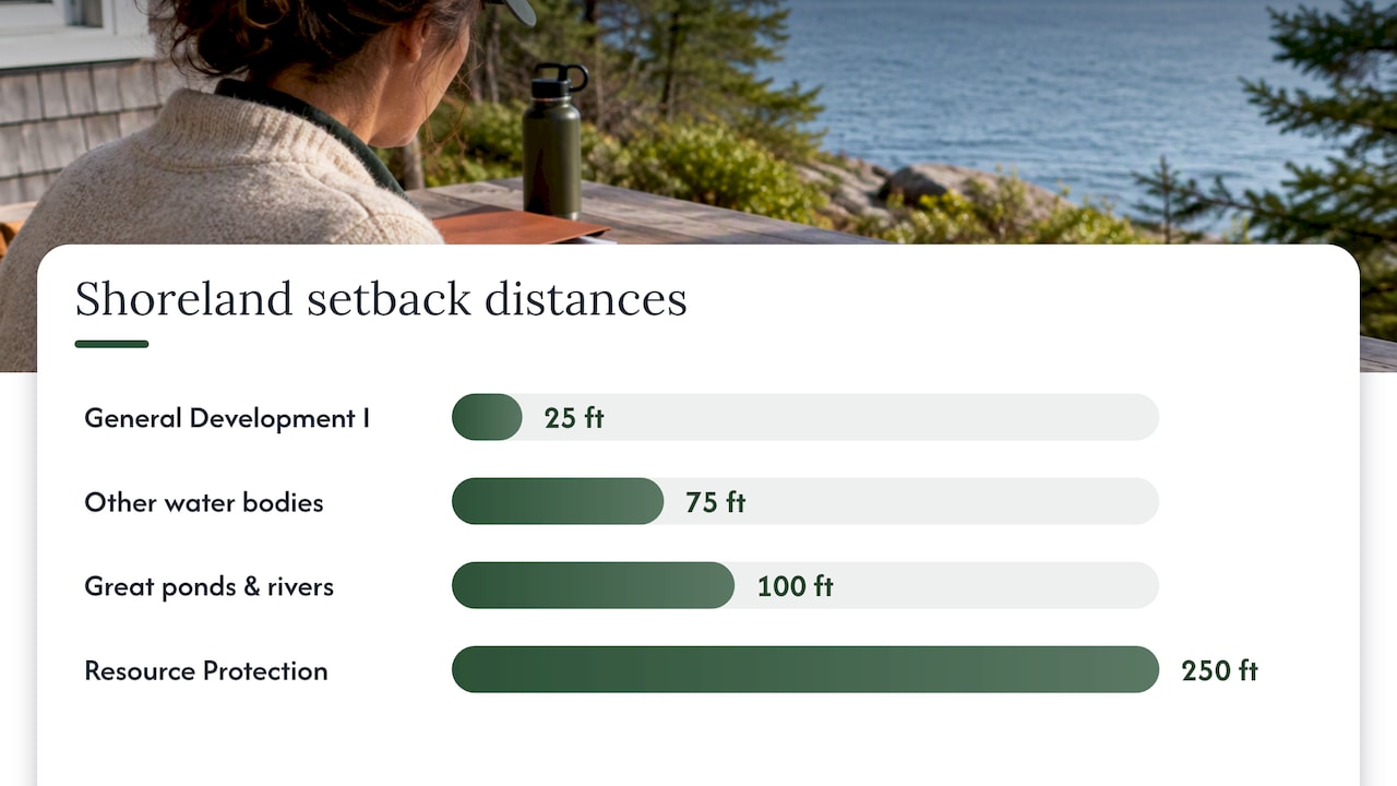
Setback distances determine how close a structure can sit to the water, and they are often the single biggest factor in whether a lot is buildable at all. The DEP’s shoreland zoning overview states that the state-mandated minimum setback is typically 100 feet from the normal high-water line of great ponds and rivers flowing to them, and 75 feet from other water bodies.
Several common variations change that baseline:
- General Development I districts sometimes allow a reduced setback of 25 feet, reflecting denser, already-developed shorefronts.
- Resource Protection districts push the setback out to 250 feet in areas with significant natural value.
- Functionally water-dependent uses, such as docks and piers, are generally exempt from standard setback requirements because they must touch the water to serve their purpose.
- Roads and driveways face their own separate setback and crossing rules, which vary by municipality.
One figure to remember: the DEP’s shoreland zoning guidance confirms that while 100 feet and 75 feet are the common statewide minimums, the actual number for any given parcel depends entirely on its municipal district, so the state minimum is a starting point for research, never a final answer.
Municipal districting is what ultimately decides the usable building envelope on a shorefront lot, which is why pulling the local zoning map matters more than memorizing the state statute.
Vegetation, clearing rules, and the buffer strip
The strip of land closest to the water, usually the first 75 to 100 feet, carries the strictest limits on cutting and clearing in the entire shoreland zone. According to Maine DEP’s clearing guidance, the buffer extends to 100 feet adjacent to great ponds classified GPA and rivers flowing to them, and 75 feet elsewhere.
Within that buffer:
- No clear-cut opening may exceed 250 square feet, measured as a single cleared patch.
- At least 40% of the volume of trees 4 inches or more in diameter must be retained over any 10-year period.
- A point system helps the Code Enforcement Officer confirm that remaining trees are well distributed rather than clustered to meet the letter of the rule while clearing the view.
- Dead, diseased, or hazardous trees can typically be removed under safety exceptions, and narrow footpaths to the water are usually allowed.
- Vegetation removed in violation of the buffer rules can trigger a restoration order requiring replanting.
Pro Tip: *Walk the buffer strip with the seller or the CEO before closing.
Shoreland zoning districts and how to read the official map
Maine’s model ordinance organizes shoreland parcels into districts that reflect how sensitive or developed the land already is. Understanding which district applies to a parcel tells you more about what you can build than the raw setback number alone.
- Resource Protection districts cover the most sensitive land, such as wetlands and steep slopes, and carry the tightest restrictions on clearing and construction.
- Limited Residential districts allow single-family development under standard shoreland setbacks and clearing rules.
- General Development districts permit denser, more commercial or marina-style uses, often with reduced setbacks.
- Laterally Split districts apply two different sets of rules to one parcel, protecting a narrow belt along the water while allowing more flexibility farther inland.
Every town with shoreland frontage maintains an official zoning map, available from the municipal office or the CEO, and that map, not a generic state chart, is the document that actually governs a specific lot.
Permits, variances, and the approval pathway
Most construction, expansion, or significant clearing within the shoreland zone requires a permit before work begins, and skipping that step is one of the most common and costly mistakes property owners make. A practical approval pathway looks like this:
- Identify the triggering activity. New construction, additions, impervious surface increases, and most vegetation clearing beyond routine maintenance typically require a permit.
- Schedule a pre-application meeting with the CEO. According to Maine DEP, this early conversation often clarifies district boundaries, setback measurements, and documentation requirements before you invest in design work.
- Prepare supporting documents. Expect to provide a site plan, a boundary or high-water-line survey, and sometimes a soils report, especially where septic design is involved.
- Address nonconformity if it applies. Title 38 MRSA §438-A and §439-A govern substantial expansions of existing nonconforming structures and set the procedure for submitting a variance request.
- Submit variance requests through the proper channel. Variances tied to shoreland setbacks generally require review that can include the commissioner, depending on the scope of the request.
Timelines vary by municipality and by whether a variance is involved, but a straightforward permit with complete documentation often moves faster than one submitted with gaps that force the CEO to request revisions.
Enforcement, penalties, and who to contact
Shoreland zoning enforcement starts locally. The municipal Code Enforcement Officer handles day-to-day administration, inspections, and initial violations, while a local board of appeals hears disputes over CEO decisions. When a municipality’s enforcement falls short, the issue can escalate to the DEP’s Shoreland Zoning Unit.
Common enforcement tools include:
- Stop-work orders issued when construction proceeds without a required permit.
- Restoration orders requiring replanting or removal of unauthorized structures.
- Fines assessed for ongoing or repeated violations.
- Documentation requests, since photos, permits, and survey records are often what resolves a compliance dispute.
For anything involving a disputed property line, an unclear high-water mark, or a legal question about nonconforming status, it’s worth bringing in a licensed surveyor, a soil scientist, or a real estate attorney before a disagreement becomes a formal violation.
Buyer and developer checklist before you buy or break ground
A shoreland parcel can look straightforward from the water and still carry real permitting risk. Before you commit to a purchase or a build, work through this sequence:
- Pull the parcel’s shoreland district and the town’s official zoning map to confirm which setback and clearing rules apply.
- Request the property’s permit history and any violation records from the municipal office.
- Get a boundary survey that identifies the normal high-water line rather than relying on an old plot plan or a seller’s estimate.
- Schedule a pre-application meeting with the CEO to confirm buildable area, septic placement, and any nonconforming status before you finalize an offer.
- Build permitting contingencies into your purchase offer so you can walk away or renegotiate if the CEO flags a problem.
Pro Tip: A permit contingency costs you nothing if the property clears review, and it can save you from inheriting someone else’s unresolved shoreland violation.
This sequence matters just as much for a buyer adding a deck as it does for a developer planning a multi-lot subdivision, because the starting questions, district, setback, and permit history, are identical.
Nonconforming structures: what changes and what doesn’t
A structure built before current setback or district rules took effect, and that no longer meets today’s standards, is considered legally nonconforming. Ownership can transfer without erasing that status, but the rules around expanding a nonconforming structure are strict.
- A nonconforming structure generally cannot expand by more than 30% of its existing footprint or floor area, a threshold set under Title 38 MRSA §438-A.
- Expansion toward the water is typically prohibited when the structure already sits within the required setback.
- Some municipalities allow special exceptions or require planning board review for expansions that would otherwise be barred.
- Rebuilding after damage or demolition often triggers a fresh review of current setback compliance rather than automatic approval to rebuild as-is.
Anyone buying a camp or cottage that predates current ordinances should ask the CEO directly whether the structure is nonconforming and what the 30% threshold would allow before assuming a renovation or addition is possible.
How a local REALTOR® helps with shoreland properties
I am a licensed REALTOR® with many years of experience in Maine’s residential market. Shoreland-zoned parcels come up often in that work, and the permitting questions rarely resolve themselves.
Part of representing a buyer or seller on these properties means coordinating a survey when the high-water line is unclear, setting up the pre-application meeting with the CEO before an offer goes in, and drafting permitting contingencies that protect a buyer if the district rules turn out stricter than expected. That groundwork, done early, keeps a shoreland transaction from stalling at inspection.
How shoreland zoning shapes septic system placement
Septic system design on a shoreland parcel has to satisfy both Maine’s subsurface wastewater rules and the shoreland setback and soil requirements that apply near water. A leach field generally needs to sit outside the minimum shoreland setback, and soil conditions close to a lake or stream, often sandy or seasonally saturated, can limit where a system is even feasible.
This is one of the most common reasons a shoreland building project stalls after purchase. A lot that looks buildable on paper may not have enough usable area outside the setback and buffer to accommodate a code-compliant septic system, particularly on older, smaller camp lots platted decades before current rules existed. A soil scientist’s evaluation, done before closing rather than after, identifies whether the lot can support a new system or whether an existing system is already grandfathered and limited in how it can be repaired or expanded. For any shorefront property without a recently inspected system, treat septic feasibility as a due-diligence item with the same weight as the setback and buffer research.
Shoreland zoning and natural resource protection
Shoreland zoning exists because what happens on land directly affects the water next to it. The MSZA’s stated purposes include protecting water quality, fish and wildlife habitat, and reducing erosion and flood damage, and the setback and buffer rules are the practical tools for achieving that.
Wetlands within the shoreland zone receive particular attention because they filter runoff and provide habitat for fish and waterfowl before water reaches open lakes or rivers. The DEP’s measurement guidance includes specific tests for when a wetland qualifies as part of the shoreland zone, which means some inland-looking parcels carry shoreland restrictions that aren’t obvious from a casual site visit. Buffer vegetation along the shoreline also slows runoff and filters sediment and nutrients before they reach the water, which is part of why the clearing limits in the buffer strip are stricter than anywhere else on a shoreland lot. Even small increases in nutrient runoff can degrade lake water quality over time, which is the underlying rationale for the 40% retention standard rather than an arbitrary number.
Common exemptions and exceptions to shoreland rules
Not every structure or activity within the shoreland zone needs a new permit or faces the standard setback. The clearest exemption applies to functionally water-dependent uses, such as docks, piers, and boat launches, which by their nature must be located at the water’s edge and are generally exempt from standard setback requirements.
Routine maintenance also tends to fall outside permitting requirements: removing a dead or hazardous tree, maintaining an existing lawn area that predates current rules, or repairing a structure without expanding its footprint typically doesn’t trigger new review. Agricultural and forestry activities sometimes operate under separate state standards rather than the shoreland ordinance directly, though they still intersect with buffer and water-quality rules in practice. Because exemptions are defined narrowly and interpreted locally, the safest approach is to confirm directly with the CEO whether a planned activity actually qualifies before assuming it does.
How shoreland zoning fits with Maine’s other environmental rules
Shoreland zoning rarely operates alone on a given parcel. A project near water may also need to satisfy Maine’s Natural Resources Protection Act for wetland or waterbody alteration, state subsurface wastewater rules for septic design, and in some cases stormwater management standards if impervious surface increases significantly.
These frameworks overlap rather than replace one another: meeting the shoreland setback doesn’t automatically satisfy a wetlands permit, and a septic system approved under state wastewater rules still has to sit outside the applicable shoreland buffer. For any project that touches a wetland, stream, or significant slope, it’s worth asking the CEO which additional state reviews apply before finalizing design plans, since missing one agency’s requirement can delay a project even after shoreland approval is in hand.
How to apply for a shoreland zoning permit
Applying for a permit starts at the municipal office, not with the state. Most towns require a completed application, a site plan showing setbacks and the normal high-water line, and a description of the proposed work before the CEO will schedule a review.
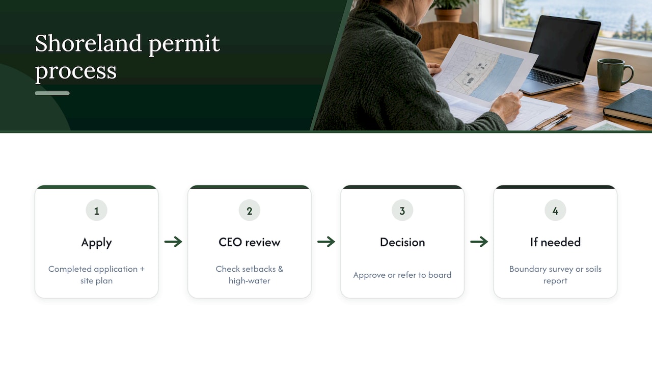
For straightforward projects, such as a small addition outside the buffer, the CEO may be able to approve the permit directly after confirming the site plan meets setback and clearing rules. Larger or more complex projects, including anything requiring a variance or touching a nonconforming structure, typically require review by the local planning board or board of appeals in addition to the CEO. Expect to provide a boundary survey if the high-water line or property line is in question, and a soils report if the project involves a new or modified septic system. Because requirements vary by municipality, calling the CEO’s office before submitting paperwork saves a resubmission cycle if something is missing.
Activities generally prohibited in the shoreland zone
Certain activities are restricted or outright barred within shoreland districts regardless of which municipality administers them.
New construction within the required setback, outside of narrow exceptions like functionally water-dependent structures, is generally not permitted. Expanding a nonconforming structure toward the water, or beyond the 30% footprint threshold, is restricted under state statute. Converting shoreland to impervious surface or lawn in ways that increase runoff into the buffer strip is also tightly controlled, since that runoff is precisely what the buffer rules are designed to prevent. Resource Protection districts add further restrictions on the type of development allowed at all, reflecting the higher sensitivity of that land.
Negotiation and due-diligence lessons from shoreland deals
The buyers who run into trouble are almost always the ones who assumed the state’s 100-foot or 75-foot minimum applied to their specific lot without checking the local ordinance, or who skipped the CEO conversation entirely to save a week. On the seller side, offering a credit for mitigation work, like buffer restoration or a septic upgrade, often closes a deal faster than arguing over whether a violation is really a problem. A permitting contingency protects both sides from guessing.
— David
How RealtorMaine helps with shoreland-zoned transactions
Buying or selling a shoreland property in Maine involves more moving pieces than a typical residential sale, and that’s exactly the kind of transaction where local, hands-on guidance pays off. We coordinate surveys when a high-water line needs confirming, set up pre-application meetings with the municipal CEO before you’re locked into an offer, draft permitting contingencies that protect your position, and help estimate realistic mitigation or septic costs so there are no surprises at the closing table.

We provide local market experience to buyers, sellers, investors, and seasonal property owners navigating shoreland rules. If you’re considering a shoreland purchase or sale, reach out through RealtorMaine to talk through the specific district, setback, and permitting questions for your property before you write or accept an offer. For sellers dealing with a nonconforming structure, this practical guide to selling nonconforming homes offers useful background on positioning the property for buyers.
This article is general information, not a substitute for advice from a qualified lawyer. Consult a qualified legal professional about your own circumstances before acting on anything here.
FAQ
What are the three types of zoning?
Zoning generally falls into residential, commercial, and industrial categories, though Maine’s shoreland ordinances add specialized districts like Resource Protection, Limited Residential, and General Development that layer additional rules onto a parcel’s base zoning. A shoreland property is often subject to both its base municipal zoning and its shoreland district simultaneously.
What is R2 zoning in Maine?
R2 zoning designations vary by municipality rather than following a single statewide definition, since each Maine town writes its own zoning ordinance. Checking the specific municipal ordinance and official zoning map is the only reliable way to confirm what an R2 district allows in a given town.
How close to a lake can you build in Maine?
Maine’s state minimum setback is typically 100 feet from the normal high-water line of great ponds and rivers flowing to them, though DEP guidance confirms municipalities can and often do require more. Some districts, like General Development I, allow a reduced 25-foot setback, while Resource Protection areas can require up to 250 feet, so the local ordinance always governs the actual number.
What does shoreland zoning mean in Maine?
Shoreland zoning refers to the land use rules that apply within a fixed distance of lakes, rivers, streams, and wetlands under the Mandatory Shoreland Zoning Act. These rules govern setbacks, vegetation clearing, and permitted construction to protect water quality and habitat, and they’re implemented through municipal ordinances rather than a single uniform state code.
Can I remove trees near my shoreline property in Maine?
Tree removal within the buffer strip is limited: no clear-cut opening may exceed 250 square feet, and at least 40% of tree volume 4 inches or more in diameter must be retained over any 10-year period under DEP clearing guidance. Dead or hazardous trees can typically be removed, but it’s worth confirming with the municipal CEO before any significant clearing project.